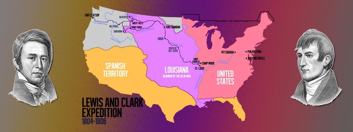
In 1803, the United States carried out the Louisiana Purchase in which it bought 2.14 million square kilometers of land. Led by Captain Meriwether Lewis and Second Lieutenant William Clark, the Lewis and Clark Expedition mapped the newly acquired Louisiana territory. One of the primary objectives of the expedition was to find a water route to the Pacific through the north-west. Though this could not be accomplished the expedition is considered a resounding success for various reasons including establishing diplomatic relations and trade with at least two dozen native American nations; establishing the presence of America over the Louisiana territory; and obtaining a wealth of scientific and geographic knowledge. Also known as the Corps of Discovery Expedition, the Lewis and Clark Expedition lasted from May 1804 to September 1806. Know more about it through these 10 interesting facts and accomplishments.
#1 ITS PRIMARY GOALS WERE TO MAP LOUISIANA TERRITORY AND TO FIND A ROUTE TO THE PACIFIC
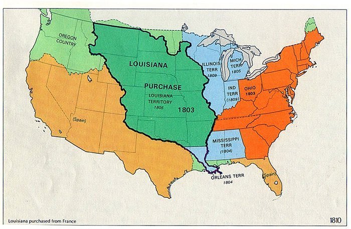
Carried out during the presidency of Thomas Jefferson, the Louisiana Purchase of 1803 doubled the size of the United States and was by far the largest territorial gain in American history. It added 2.14 million square kilometers of land to the United States that stretched from the Mississippi River to the Rocky Mountains and from the Gulf of Mexico to Canada. President Jefferson commissioned the Lewis and Clark Expedition shortly after the Louisiana Purchase to map the newly acquired territory and to establish American presence there before the European powers tried to claim it. Apart from this, the major reason for the expedition was to find a water route to the Pacific through the north-west, which in turn would increase trade opportunities. Other objectives included studying the area’s plants, animal life and geography; and establishing trade relations with local American Indian tribes.
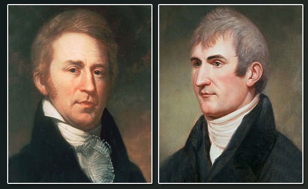
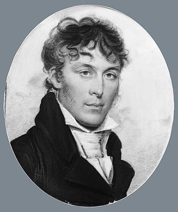
#2 THE EXPEDITION GETS ITS NAME FROM ITS LEADERS
In 1803, President Thomas Jefferson commissioned the Corps of Discovery, a select group of volunteer soldiers who formed the nucleus of the Lewis and Clark Expedition. Due to this, the expedition is also known as the Corps of Discovery Expedition. Jefferson selected 28-year-old Army captain, Meriwether Lewis, to lead the expedition. Lewis, in turn, selected a former Army comrade, 32-year-old Second Lieutenant William Clark, to be co-leader of the Corps of Discovery. Though Clark officially only held the rank of Second Lieutenant at the time, Lewis concealed this from the members of the expedition and always referred to Clark as “Captain”. Lewis entrusted the job of recruitment to Clark. He wanted the enlisted men to be excellent hunters and possess skills that would ensure their survival in the wilderness. He also wanted men who were brave, unmarried and healthy.
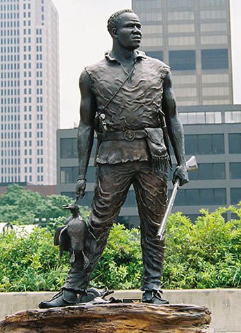
#3 IT INCLUDED AN AFRICAN AMERICAN SLAVE NAMED YORK
The Corps of Discovery included Clark’s personal slave named York. Though not an official member, York made the entire journey from St. Louis to the Pacific and back. He was a valuable member of the expedition for his skills as a hunter. York enjoyed certain amount of freedom during the expedition and, hence, after the expedition, Clark had difficulty compelling York to resume his former status. York’s ultimate fate is not known with certainty but there is speculation that he was freed by Clark. Renowned 20th century American sculptor Ed Hamilton created a statue of York to commemorate his participation in the Lewis and Clark expedition. In 2001, President Bill Clinton posthumously granted York the rank of honorary sergeant in the United States Army.
#4 THE FLOYD RIVER IS NAMED AFTER A MEMBER OF THE EXPEDITION
The Lewis and Clark Expedition started on May 14, 1804 as the Corps of Discovery departed from Camp Dubois. It followed the Missouri River westward and soon, it passed La Charrette, the last Euro-American settlement on the river. Sergeant Charles Floyd, one of the members of the Corps of Discovery, suffered from acute appendicitis and died on August 20, 1804. He remained the only member to die during the entire expedition. Charles Floyd was buried at a hill by the river now named as Floyd’s Bluff after him. His burial site was marked with a cedar post on which was inscribed his name and day of death. The Floyd River, a tributary of the Missouri at which the expedition camped after his death, is named after Charles Floyd.
#5 THE EXPEDITION WOULD HAVE PROBABLY FAILED WITHOUT THE HELP OF NATIVE AMERICAN TRIBES
The Corps of Discovery established relations with around two dozen native American tribes, then referred to as Indian nations. Without the help of these tribes, the members of the expedition would have probably starved during the harsh winters or become hopelessly lost in the vast ranges of the Rocky Mountains. The Corps spent their first winter near present-day Washburn, North Dakota. They resided among the Mandan, a Native American tribe. On the north bank of the Missouri River, the Corps constructed a log fort which they called Fort Mandan, in honor of the Mandan tribe. The explorers spent their first winter hunting, gaining information about the route ahead and making tools that they would later trade for supplies.
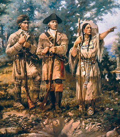
#6 A NATIVE AMERICAN WOMAN NAMED SACAGAWEA PROVED VERY HELPFUL FOR THE EXPEDITION
While the expedition wintered at the Mandan settlement, they met a French-Canadian trader Toussaint Charbonneau and his young wife Sacagawea. Sacagawea belonged to Shoshone, a native tribe. She had been kidnapped when she was 12 and sold to Charbonneau as a wife at the age of 13. A few weeks after meeting with the expedition, Sacagawea gave birth to her first child. Lewis and Clark knew that they would encounter several Shoshone tribes along the way. Hence they decided to hire the Charbonneau family to accompany them. Sacagawea proved to be very helpful acting as interpreter; and making sure that the native Americans realized the peaceful intent of the expedition. During the expedition, Sacagawea reunited with her brother Cameahwait, who had become chief of the tribe. The Shoshone agreed to barter horses to the expedition and to provide guides to lead them.
#7 THE EXPEDITION DIDN’T FIND THE WESTWARD WATER PASSAGE TO THE PACIFIC
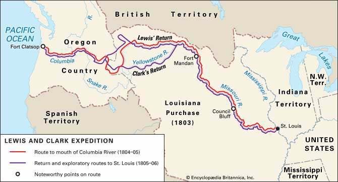
In April 1805, the Corps of Discovery expedition set out again continuing up the Missouri River and into Montana Territory. Although the expedition had believed that the Missouri would connect to another great river leading to the Pacific, it found that no such passage existed. It had to travel by land till it reached Clearwater and Snake Rivers. On November 7, 1805, the expedition sighted the Pacific Ocean for the first time. It arrived there two weeks later. It began its second winter camping on the north side of the Columbia River. On November 24, the party voted to move their camp to the south side of the Columbia River. Sacagawea and York were both allowed to participate in the vote. So this may have been the first time in American history that a woman and a slave were allowed to vote. On the south of Columbia River, the expedition constructed Fort Clatsop, where they spent their winter.
#8 LEWIS AND CLARK EXPEDITION IS CONSIDERED A RESOUNDING SUCCESS
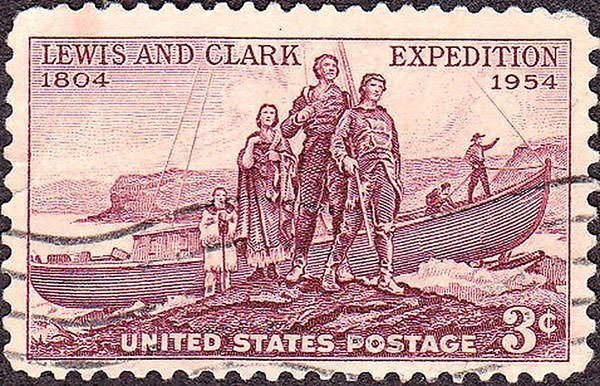
On March 23, 1806, the Lewis and Clark expedition began its journey home. On July 3, before crossing the Continental Divide, Lewis and Clark split up to explore more area. They re-united on the Missouri River and arrived back in St. Louis on September 23, 1806, ending the expedition. The members of the Lewis and Clark expedition were the first Americans to cross the Continental Divide; the first to see Yellowstone; to enter into Montana; and to produce an official description of these different regions. They gained an understanding of the geography of the Northwest and produced the first accurate maps of the area. Together, Lewis and Clark drew about 140 maps. The expedition is considered a resounding success. Lewis and Clark have been commemorated and honored over the years on various coins, currency and commemorative postage stamps, as well as in a number of other capacities.
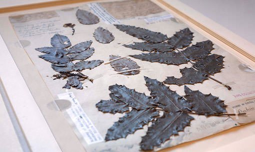
#9 THE EXPEDITION OBTAINED A WEALTH OF SCIENTIFIC AND GEOGRAPHIC KNOWLEDGE
Though they did not find a continuous waterway to the Pacific Ocean, the Corps of Discovery met their objective of reaching the Pacific. They located a land route that led from the upper end of the Missouri River to the Columbia River, which in turn ran to the Pacific Ocean. They were able to map and establish the presence of the United States in the recently acquired Louisiana territory. The expedition met its objective related to American Indian tribes by establishing diplomatic relations and trade with at least two dozen indigenous nations. They also observed and recorded information regarding the lifestyles, customs and social codes of various native Americans. The Corps of Discovery constantly collected information about plants, animals and birds. The various plant, seed and mineral specimens they brought back provided crucial information about the natural habitat, flora and fauna of the region.
#10 THE SPANISH MADE AN UNSUCCESSFUL ATTEMPT TO INTERCEPT THE EXPEDITION
In March 1804, before the Lewis and Clark expedition began, the Spanish in New Mexico feared that Americans would encroach on territory claimed by Spain; and that the expedition might lead to the seizure of their gold-rich territories in the southwest. On the suggestions of U.S. Army General James Wilkinson, a Spanish spy, the Spanish governor of New Mexico dispatched four armed expeditions of 52 soldiers, mercenaries and Indians under the command of Pedro Vial. The expeditions aimed to intercept the Corps of Discovery and bring them back in chains. However, the Spanish search parties failed to locate the American explorers. This was primarily because the Lewis and Clark expedition was covering 70 to 80 miles (110 to 130 km) a day; and it was very difficult to locate them in the vastness of the frontier.
A pedagogical experience.