
The Mississippi River, also known as Misi-ziibi, is one of the most important rivers in North America as it has played a key role in the history of the continent. It originates at Lake Itasca in Minnesota, flows south across the continental interior collecting waters of its tributaries, and drains into the Gulf of Mexico. Mississippi is the 15th largest river in the world by discharge volume; and the second longest river in North America. It also has the 4th largest river basin in the world which is home to some of the most diverse population of fauna and has been called the “mother fauna” of North America.
The Mississippi has played a tremendous role in the lives of the people living in its basin for more than two millennia supporting their population through its water and fertile plains, among other things. Moreover, it continues to be a vital factor in the current economy of the United States because of the agricultural activities, port system, manufacturing industries and the booming tourism industry. However, it is seeing a rise in pollution in recent years due to human activity. Know about the geography, history, significance and ecology of the Mississippi River through these 10 interesting facts.
#1 MISSISSIPPI IS THE SECOND LONGEST RIVER IN NORTH AMERICA
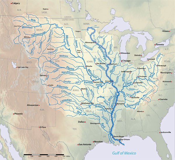
The Mississippi River has a length of 3,730 km (2,320 mi). This makes it the second longest river in North America after the Missouri River, which has a length of 3,767 km (2,341 mi). Moreover, the Mississippi-Missouri-Jefferson river system has a length of 6,275 km (3,902 mi). This makes it the fourth longest river in the world after the Nile, the Amazon and the Yangtze. In terms of discharge, the Mississippi is the fifteenth-largest river by volume in the world with an average discharge of around 16,792 cubic m/s (593003.88 cubic ft. /s). The source of Mississippi River is Lake Itasca, a glacial lake situated in northern Minnesota. The Mississippi is situated entirely within the United States. After originating in the state of Minnesota, it runs southward touching or passing through the states of Wisconsin, Iowa, Illinois, Missouri, Kentucky, Tennessee, Arkansas, Mississippi and Louisiana. Finally it forms the Mississippi River Delta as it empties into the Gulf of Mexico, part of the Atlantic Ocean.

#2 OHIO RIVER IS Its LARGEST TRIBUTARY BY VOLUME
The Mississippi may be divided into three parts: the Upper Mississippi, the Middle Mississippi and the Lower Mississippi. In its upper course, it flows approximately 2,000 km (1,250 mi) from its headwaters to its confluence with the Missouri River at St. Louis, Missouri. The middle course of the Mississippi stretches for about 310 km (190 mi) to its confluence with the Ohio River at Cairo, Illinois. In its lower course, the Mississippi runs for a distance of about 1,600km (1,000mi) and finally empties in the Gulf of Mexico.
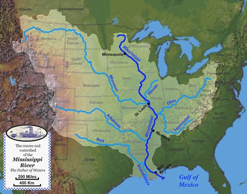
The Mississippi is fed by numerous tributaries of which the five most important are Arkansas River, Illinois River, Missouri River, Ohio River and the Red River. The major right bank tributaries of the Mississippi are Missouri, Arkansas, White and Red rivers. Of these, the Missouri River is the longest tributary of the Mississippi with a length of 3,767 km (2,341 mi). The major left bank tributaries of the Mississippi are Illinois, Ohio, Wabash, Cumberland and Tennessee rivers. Of these, the Ohio River is the largest tributary by volume of the Mississippi. As it flows into the Gulf of Mexico, Mississippi River forms the Mississippi River Delta, which covers an area of about 12,000 sq. km (4,700 sq. miles) and is the 7th largest river delta on earth.
#3 ITS RIVER BASIN IS THE FOURTH LARGEST IN THE WORLD
The total drainage area of the Mississippi-Missouri river system is estimated to be around 3,202,185 sq. km (1,236,371 sq. miles). This makes it the largest river basin in the United States and the fourth largest river basin in the world behind that of Amazon, Congo and Nile. The Amazon for comparison drains about 7.1 million sq. km (2.7 million sq. mi). The watershed extends from the Allegheny Mountains in the east to the Rocky Mountains in the west. Only 1% of the total drainage basin lies in Canada while the rest 99% lies entirely within the boundaries of the United States. The drainage basin of Mississippi-Missouri covers all or parts of 32 U.S. states and two Canadian provinces. It thus encompasses 41 percent of the area of continental United States and 15% of North America.
#4 IT IS CALLED THE “MOTHER FAUNA” OF NORTH AMERICA
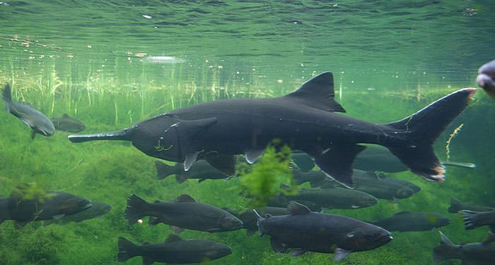
The Mississippi River Basin is regarded as one of the most significant ecological areas in the world due to its highly diverse fauna. Thus, it has been called the “mother fauna” of North American fresh water. The Mississippi basin is home to hundreds of species of animals. Animals usually seen in the wetlands and forests of the upper Mississippi river valley include white-tailed deer, bald eagles, otters, muskrats and wild turkeys. The southern portion of the river and its delta is also home to numerous animals including crawfish, shrimp, catfish, snakes, turtles, alligators, herons, spoonbills and leeches. The Mississippi river contains around 260 species of fish, which is about 25 percent of all fish species in North America. Many of these fish species are endemic to the region like the paddlefish, sturgeon, gar and bowfin. In addition to fish, several species of turtles and American alligators are native to the Mississippi basin. Apart from this, 60 percent of all North American birds use the river basin as their migratory flyway. These include about 8 million ducks, geese, swans and wading birds.
#5 ITS NAME COMES FROM AN ANISHINAABE WORD MEANING “GREAT RIVER”
The River Mississippi was referred to as Misi-iibi by the ancient Native Americana who lived along its banks and used the river for sustenance and transportation. The meaning of the word is “Great River”. The French explorers who reached the river called it Messipi, which is the French rendering of the Anishinaabe word Misi-iibi. The Anishinaabe is the group name for several tribes living in the northern parts of the United States and Canada. Anishinaabe living in the upper Mississippi River basin include the Ojibwe and Potawatomi tribes. The name Mississippi, which we use for the river today, comes from the French rendering of the Native American word for the river. The state of Mississippi, which is the 32nd largest and 34th most populous of the 50 states in the U.S., is named after the river, which flows along its western boundary. Due to seasonal flooding, between December to June, the Mississippi river creates a fertile floodplain in the Mississippi Delta and blesses its namesake with good scope for cultivation.
#6 A NATIVE AMERICAN CIVILIZATION FLOURISHED ALONG THE RIVER FROM 800 CE TO 1600 CE
According to a study, the geological age of Mississippi River is 60,000 years. The Mississippi River Basin was first settled by hunter-gatherer Native American people. Human activity along the river dates back to the 4th millennium BCE; and by around 1000 BCE, the lifestyle gradually became more settled with increasing evidence of shelter construction, pottery, weaving and other practices. Although most of the native Americans were forest dwelling hunter-gatherers, many groups also practiced aquaculture and agriculture along the Mississippi. The river served as a means of transportation for them and from it they took the fish which was a mainstay of their diet.
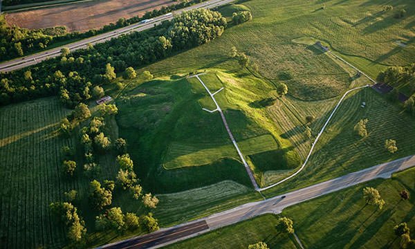
From around 800 CE to 1600 CE, an advanced civilization flourished along the Mississippi known as Mississippian culture today. It consisted of a series of urban settlements and villages which were connected by loose trading networks. The largest city of this Native American civilization was Cahokia, which contained a population between 10,000 and 20,000 people. Spread over an area of six square miles, Cahokia was larger than London at the time. Today, native American tribes inhabiting the Mississippi basin include Cheyenne, Sioux, Ojibwe, Potawatomi, Ho-Chunk, Fox, Kickapoo, Tamaroa, Moingwena, Quapaw and Chickasaw.
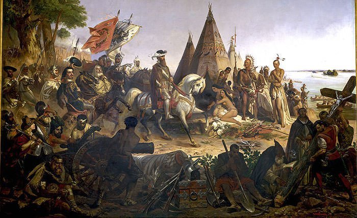
#7 HERNANDO DE SOTO WAS THE FIRST EUROPEAN TO REACH THE MISSISSIPPI
Spanish explorer Hernando De Soto and his group are the first recorded Europeans to reach the Mississippi in 1541. Ironically, De Soto was buried in the waters of the river he discovered after he died on May 21, 1542. In 1682, French explorer Robert de La Salle reached the mouth of the Mississippi and claimed the entire valley in the name of France. The United States ultimately secured effective control of the river when it bought the territory from France in the Louisiana Purchase of 1803, the largest real estate transaction in human history.
In the 1800s, steamboats became a popular means to transport goods and travelers along the Mississippi. Famous American writer Mark Twain has covered the steamboat commerce which took place from 1830 to 1870 on the river in his 1883 memoir Life on the Mississippi. When the American Civil War broke out in 1861, control of the Mississippi was a major objective for both the Union and the Confederate forces. The successful Siege of Vicksburg (May 18 – July 4, 1863) by the Union army gave them the last major Confederate stronghold on the Mississippi River. The Siege of Vicksburg is regarded as a major turning point of the American Civil War.
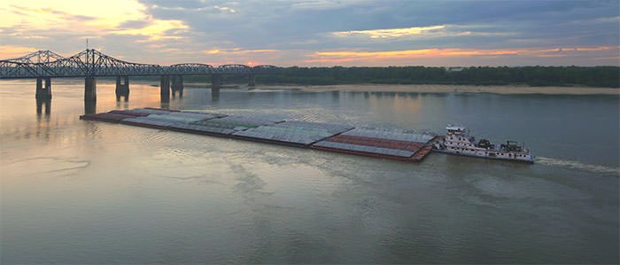
#8 MISSISSIPPI CONTRIBUTES MORE THAN $400 BILLION TO THE U.S. ECONOMY
The Mississippi River plays a major role in local, regional, state and national economies, both directly and indirectly. It remains vital to the economic prosperity of the region through its rich and diverse ecosystem; providing a commercial transportation system, supplying water and also as a recreational resource. Research shows that the river supports nine key economic sectors: manufacturing; energy production; commercial navigation; tourism; mineral extraction; water supply; agriculture; outdoor recreation; and commercial harvest. According to studies, it is estimated that the river generates $405 billion revenue annually and supports 1.3 million jobs. Economic sectors in the Upper Mississippi region generate more than $253.2 billion annually, supporting 755,000 jobs; while the Lower Mississippi region generates $151.7 billion in annual revenue and employs 585,000 people. Manufacturing is the dominant sector in both the regions providing 80% and 70% of the revenue in the upper and lower regions respectively.
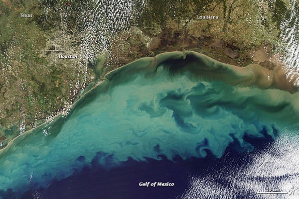
#9 POLLUTION OF THE MISSISSIPPI HAS CREATED A DEAD ZONE IN THE GULF OF MEXICO
The Mississippi River is experiencing major pollution problems. Agricultural runoff is the primary source of polluting the river. The use of excess fertilizer and the presence of excessive amounts of animal waste leads to a major issue as the nutrients are carried into a body of water. Agricultural runoff adds nutrients like Nitrogen and Phosphorus to the water system causing it to become eutrophic (nutrient rich). Algae grow and die at high rates in nutrient rich areas and use up the nutrients. This is turn blocks the sun from penetrating the water surface inhibiting photosynthesis. All this results in producing dead zones in the Gulf of Mexico. Dead zones are areas which have less than required oxygen to support most marine life in bottom and near-bottom water. The dead zone in the Gulf of Mexico is an area that runs along the Louisiana and Texas coast lines. According to the United States Geological Survey, excess nutrients delivered from the Mississippi River is the primary cause of this dead zone.
#10 IT FLOWED BACKWARD DUE TO AN EARTHQUAKE
The New Madrid Seismic Zone is a major seismic zone stretching to the southwest from New Madrid, Missouri. It is a prominent source of earthquakes in southern and mid-western United States. Moreover, it was responsible for four of the largest North American earthquakes in recorded history and has the potential to produce large earthquakes in the future. The Mississippi River flows through the vicinity of the New Madrid seismic zone in southern and mid-western United States. Major seismic activities in the zone in 1811-1812 destroyed several settlements along the Mississippi River, caused bank failures and brought about shifts in the course of the Mississippi River and its tributaries. The 1811–12 New Madrid earthquakes, which took place between December 1811 and March 1812, were the most powerful in the history of the United States. On February 7, 1812, an 8.8-magnitude earthquake formed temporary waterfalls on the Mississippi River. Moreover, soil beneath the Mississippi River rose due to which the Mississippi temporarily changed its course so that it flowed backward for several hours.