The Yangtze River, known primarily as Chang Jiang in China, is one of the most important rivers in the world running across China from west to east. It originates in the Tanggula Mountain and moves eastward finally emptying into the East China Sea. The Yangtze is the longest river in Asia and the third longest river in the world. Moreover, it is the longest river to run its entire course within the boundaries of only one nation. The Yangtze has played a tremendous role in the Chinese civilization for more than two millennia supporting its population through its water and fertile plains, among other things. Moreover, it continues to be a vital factor in the current economy of China because it is the country’s principal waterway; and its basin is China’s great granary. As the Yangtze flows through a wide array of ecosystems, it is home to numerous endemic species. However, several of these are endangered and some are on the verge of extinction due to human activities. Moreover, like many rivers around the world, the rising pollution levels of the river has become a grave concern. Know about the geography, history, significance and ecology of the Yangtze River through these 10 interesting facts.
#1 YANGTZE IS THE LONGEST RIVER IN ASIA
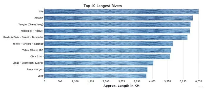
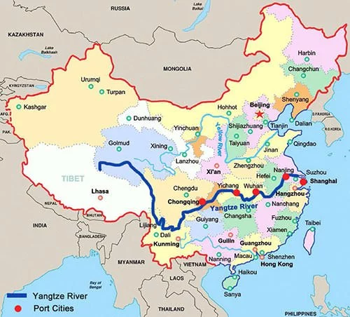
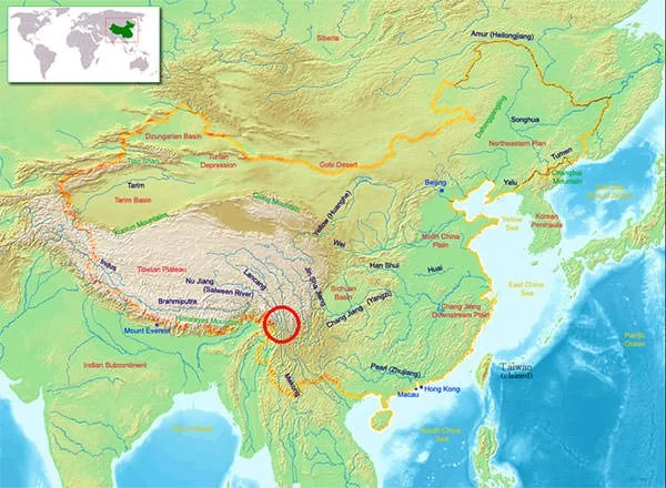
The River Yangtze is 3,915 miles (6,300 kilometers) long, making it the longest river in both China and Asia and the third longest river in the world after the Nile and the Amazon. In terms of discharge, the Yangtze is the sixth-largest river by volume in the world with an average discharge of around30,166 m3/s (1,065,302.24 cubic ft./s). This is more than ten times the annual discharge of the much longer River Nile and more than four time that of the River Indus. The Yangtze flows entirely within China’s territory and runs its course eastward through Qinghai-Tibet Plateau, Sichuan, Yunnan, Chongqing, Hubei, Hunan, Jiangxi, Anhui, Jiangsu and Shanghai. Finally, it merges into the East China Sea near the Jiangnan region. The Yangtze is the longest river in the world which lies completely within the boundaries of a single nation
#2 THE YANGTZE ORIGINATES IN JARI HILL IN THE TIBETAN PLATEAU
The source of the Yangtze is Jari Hill, a place of high elevation (16,942 feet above sea level) in the Tanggula Mountains, a mountain range in the central part of the Tibetan Plateau. It is only recently, in late 20th century, that the source of the Yangtze was discovered. The Dangqu River, or Dam Chu, which rises in the Tanggula Mountains is the geographic head-water of the Yangtze. However, the People’s Republic of China (PRC) recognizes Ulan Moron or the Tuotuo River as the source of Yangtze. Ulan Moron originates as melt-off from the Geladandong glaciers, a snow-covered peak located in southwestern Qinghai province of China. Ulan Moron then runs to a confluence with the Dangqu River to form the Tongtian River.
The confluence of the Tongtian River with the Batang River near Yushu in Qinghai Province forms the Jinsha River, the name used for the upper course of the Yangtze. The Jinsha joins the Min River at Yibin in Sichuan to form the Yangtze, or Chang Jiang. Since the source of the Yangtze was not ascertained till recently, the Chinese use different names for different sections of the river. Through its course it is called the Tuotuo River (‘Tearful River’); Tongtian River (‘River Passing Through Heaven’); Jinsha River (‘Gold Sand River’); and finally Chang Jiang (‘Long River’).
#3 IT HAS OVER 700 TRIBUTARIES
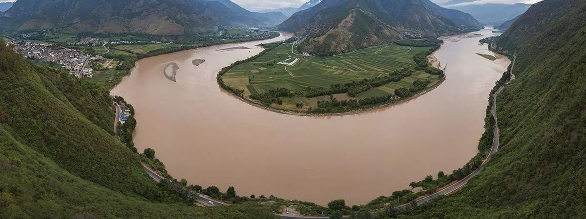
The Yangtze may be divided into three parts: the Upper Course, the Middle Course and the Lower Course. In its upper course, it flows across the Plateau of Tibet and descends through deep valleys in the mountains east of the plateau. Two other great rivers, the Mekong and the Salween, flow side by side with the Yangtze in its upper course. The middle course of the Yangtze stretches for about 630 miles (1,010 km) between the cities of Yibin in Sichuan province and Yichang in Hubei province. In its lower course, the Yangtze flows through the lowland plains of east-central China and finally empties in the East China Sea near the city of Shanghai.
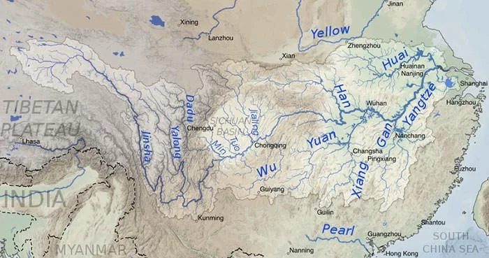
The Yangtze is fed by approximately 700 tributaries, including eight principal rivers. The major left bank tributaries of the Yangtze are Yalung, Min, Jialing and Han rivers. Of these, the Han River is the longest with a length of 952 miles. The major right bank tributaries of the Yangtze are Wu, Yuan, Xiang and Gan rivers. Of these, Wu River, which is 710 miles long, is the longest. As the river flows into the East China Sea, it forms the Yangtze River Delta, which covers an area of about 99,600 sq. km (38,500 sq. miles) and is one of the most densely populated regions on earth.
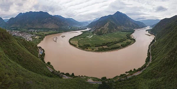
#4 A STRETCH OF YANGTZE IS PART OF ONE OF THE MOST BIO-DIVERSE REGIONS IN THE WORLD
The Three Parallel Rivers Area is a region in Yunnan province of China that lies within the drainage basins of three major Chinese rivers; Lancang (Mekong), Nujiang (Salween) and the Yangtze. In the area, the three rivers run roughly parallel to one another for a distance over 300 km, though separated by high mountain ranges. These great rivers and the ecology is protected by a national park 310 km by 180 km in size. The Three Parallel Rivers of Yunnan Protected Areas is a UNESCO World Heritage Site. It consists of fifteen protected areas, in eight geographic clusters. In its description of the area, the UNESCO mentions: “(It) is claimed to be the most bio-diverse and least disturbed temperate ecosystems in the world”.
The Three Parallel Rivers Area is home to around 6,000 species of plants, many of which are endemic; 173 species of mammals, of which 81 are endemic; and 417 species of birds, of which 22 are endemic. The demographics of the area are also notable as it is home to many minorities found in Yunnan province including the Derung, the Tibetan people, the Nu people, Lisu, Bai, Pumi and Naxi.
#5 YANGTZE HAS BEEN VITAL TO CHINESE HISTORY, CULTURE AND ECONOMY
According to a study, the geological age of Yangtze River is 45 million years. It has played a major role in the history, culture and economy of China. Human activity along the river dates back to 27,000 years ago; and by 5th millennium BC, the lower Yangtze was a major population center. Numerous ancient Chinese tribes relied on the water of the Yangtze and thus the river is culturally very important to the nation. From the time of the Han Dynasty (206 BCE – 220 CE), the Yangtze became more and more important to China’s economy. As the Chinese developed irrigation systems along the river, agriculture produce became stable and abundant.
By the Song Dynasty (960 CE – 1279CE), the area along the Yangtze had become among the wealthiest and most developed parts of the country. Moreover, the river has been the backbone of China’s inland water transportation system for almost 2,000 years. Today, the Yangtze River Basin contributes around 40% of the GDP of China. It is China’s most important economic engine and the economic belt, anchored by the Yangtze River Delta, is a powerhouse of industrial output for top-notch multinationals. The Yangtze River Delta Economic Zone is dominated by Shanghai which is mainland China’s financial center, as well as by other important economic hubs like the cities of Nanjing, Suzhou, Hangzhou, Ningbo and Xuzhou.
#6 ITS BASIN COULD ACCOUNT FOR 8% OF THE GLOBAL GDP BY 2050
The total drainage area of the Yangtze is estimated to be698,265 sq. miles (1,808,500 sq. km). This makes the Yangtze drainage basin the 12th largest river basin in the world. Moreover, the Yangtze drainage basin comprises one-fifth or 20% of the land area of China; and is home to nearly one-third of the country’s population. The Yangtze River basin stretches from the glacial melt-waters of the Tanggula Mountains in Tibet to the fertile alluvial plains of Yangtze River Delta in Shanghai. It plays a central role in Chinese agriculture, industry and travel. Most of the water use in the basin is for irrigation, primarily for water-intensive rice production.
The basin is also considered as the great granary of China. This is due to the fact that the amount of grain production which takes place in this region is enough to feed half of the country’s population. Among the crops, rice accounts for 70 percent of the production. The GDP of the Yangtze River Basin in 2010 was US$1796 billion, around 40% of the GDP of China. Moreover, according to research by Frontier Economics, it is estimated that the Yangtze River Basin will account for almost 8% of global GDP by 2050.
#7 THREE GORGES DAM ON YANGTZE IS THE WORLD’S LARGEST HYDROPOWER PROJECT
The Three Gorges Dam, which became fully functional on July 4, 2012, is a hydroelectric gravity dam that spans the Yangtze River. It is located about 1,000 miles (1,610 km) west of Shanghai, in Yiling District, Yichang, Hubei province. It’s named for its location near the three gorges at the foot of the western Wu Shan Mountains. With a width of 2,335 m (7,661 ft.) and a height of 185 m (607 ft.), the Three Gorges Dam is the largest hydroelectric dam in the world.
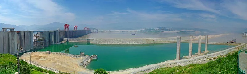
In terms of installed capacity, it has been the world’s largest power station since 2012. It has 34 generators; 32 main generators, each with a capacity of 700 MW; and two plant power generators, each with capacity of 50 MW; making a total capacity of 22,500 MW. Moreover, it can hold back more than five trillion gallons (19 billion cubic meters) of water and has a total surface area of 1,045 sq. km (403 sq. mi). Apart from producing electricity, the dam increases the Yangtze River’s shipping capacity, reduces the potential for floods downstream by providing flood storage space and is considered as a major move toward limiting greenhouse gas emissions.
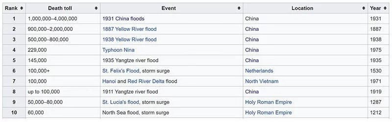
#8 FLOODING OF THE YANGTZE HAS RESULTED IN CONSIDERABLE LOSS OF LIFE
Though Yangtze has been a major source of livelihood for the Chinese for centuries, it has flooded periodically and has often caused considerable destruction of property and loss of life. The primary flood region is the lower course, downstream of the Three Gorges Dam, an area in which the river flows through low-lying terrain dotted by lakes, marshes and meandering streams. The 1931 China floods, or the 1931 Yangtze–Huai River floods, were a series of catastrophic floods that devastated China. They are one of the deadliest natural disasters ever recorded. The 1931 China floods had an estimated death toll between 3.7 million and 4 million. The Yangtze also flooded in 1954, causing an estimated loss of life of around 33,000 people; in 1998, resulting in 3,704 dead, 15 million homeless and $26 billion in economic loss; and most recently in 2016, causing US$22 billion in damages.
The reasons for the floods is usually sustained heavy rains in the lower Yangtze basin and the reduced the capacity of the area to handle intense rains due to deforestation and reduced lake size which decreases flood storage capacity. However, with the assistance of technology, Chinese government has been successful in strengthening its flood resistance ability in the recent years with advanced flood observation system and the introduction of cutting-edge equipment.
#9 ITS MOST FAMOUS FISH WAS DRIVEN TO EXTINCTION BY HUMAN ACTIVITY
Yangtze is one of the most species rich rivers in Asia. In a major 2011 study, a total of 416 species of fish were recorded, out of which 178 fish species are endemic to the Yangtze. The most diverse orders are Cypriniformes, Siluriformes, Perciformes, Tetraodontiformes and Osmeriformes. The most famed faunal member of the Yangtze was however the freshwater Yangtze River dolphin (Lipotes vexillifer). Known as Baiji (‘white-finned dolphin’), it was regarded as the goddess of protection by local fishermen and boatmen in China. It is in fact nicknamed ‘Goddess of the Yangtze’.

Fossil records suggest that the dolphin first appeared 25 million years ago. Moreover, it was one of only four true freshwater dolphins in the world. The population of the Baiji started to decline with the industrialization of China as the nation made heavy use of the Yangtze for fishing, transportation and hydroelectricity. Due to this, the Baiji was driven to extinction. The last known living baiji died in 2002. It is regarded as the first dolphin species driven to extinction due to the impact of humans. Other critically endangered species in the Yangtze include narrow-ridged finless porpoise and the Yangtze alligator.
#10 YANGTZE TRANSPORTS MORE PLASTIC TO THE SEA THAN ANY OTHER RIVER
The pollution of the Yangtze is a major issue that China must resolve at the earliest. The Yangtze has become one of the most polluted rivers in the world due to several reasons including the discharge of waste from pig farms as well as of untreated industrial and municipal sewage. In September 2012, the Yangtze river near Chongqing turned red from pollution. Moreover, in recent years, the river has increasingly suffered from plastic pollution, threatening marine life in the East China Sea and beyond.
According to reports, the Yangtze carries 1.5 million tons of plastic into the sea each year, the most for any river in the world. In a 2015 study published by the journal Science, China tops the list of the largest emitters of oceanic plastic pollution worldwide. In 2017, when the Chinese government realized the gravity of the issue, they stepped up an ambitious plan to protect the Yangtze by designating ecological redlines which prohibit heavy and chemical industry projects within one kilometer of the Yangtze and its major tributaries.